







Follow Us!
facebook
twitter
instragram
vimeo
youtube
MENU
  • About
    • About The Bird’s Head Seascape
    • Contact Us
    • Close
  • News-Topics
    • NEWS CATEGORIES
    • Terra Papua
    • Diving
    • Conservation/Science
    • Photography
    • Regional
    • Berita Terkini
    • ReShark
    • Close
  • Galleries
  • Partners
  • Resources
    • Library Research Categories
      • Oceanography
      • Biodiversity, Taxonomy, Ecology
      • Conservation
      • Social Science & Development
    • Media, Fact Sheets & Legal
      • Media
      • Fact Sheets
      • Legislation & Legal Documents
      • About Blue Abadi Fund
      • Indonesian Publications
    • ID Database Projects
        • manta-id-action_btn

        • whaleshark-id-action_btn-300×83

        • Books & Regional Info
        • RAMPAActionButton
    • Close
  • Visitor Info
    • Diving in the Bird’s Head Seascape
    • Travel Information
    • Land Adventures, Guides, and Resorts
    • Procedures for Private Vessels
    • Close
  • Maps
    • Raja Ampat Maps
      • Wayag To Uranie
      • Kawe
      • Alyui
      • West Waigeo
      • Fam Penemu
      • Dampier Strait
      • Batanta
      • Kofiau
      • Misool
    • Triton Bay
    • Cenderawasih Bay
    • Bomberai / Fakfak
      • The Pisang Islands
      • Batu Putih
      • Fakfak and Panjang Island
      • Semai Island & Seamounts
      • Tanjung Turkanggur
      • North Teluk Sebakor
      • Karas Island & Seamounts
      • Tongerai & Toran
      • Momon
      • Cape Papisol
    • Marine Protected Areas
      • MPA: Pratinjau KKP Raja Ampat
      • MPA: Perairan Kepulauan Ayau Asia
      • MPA: Teluk Mayalibit
      • MPA: Selat Dampier
      • MPA: Perairan Kepulauan Misool
      • MPA: Perairan Kepulauan Kofiau Boo
      • MPA: Perairan Kepulauan Fam
      • MPA: Kaimana MPAs
      • MPA: Taman Pesisir Teluk Nusalasi
      • MPA: Taman Pesisir Teluk Berau
      • MPA: Jeen Womom Coastal Park
      • MPA: Cendrawasih Bay National Park
      • MPA: Kepulauan Padaido
      • MPA: KKP Maksegara (Makbon)
      • MPA: TCBFM Teluk Bintuni
      • MPA: KKP Sorong Selatan
      • MPA: Taman Wisata Perairan Raja Ampat
    • Close

Blog Post

Bird's Head Seascape > Biodiversity > Fakfak & Panjang Island: New Divesites in the Bomberai/Fakfak
0 Comment

Fakfak & Panjang Island: New Divesites in the Bomberai/Fakfak

23 Feb 2023
Burt Jones
Bird's Head Seascape, Bomberai, Bomberai peninsula, Conservation, Coral Triangle, cruising, discovery, diversity, diving, ecology, endangered species, environment, Fakfak, Indonesia, initiatives, Marine Protected Area, MPA, news, Panjang Island, photography, protected areas, Science, seamount, snorkeling, sustainability, tourism, underwater photography, West Papua

We are posting a series of recently surveyed dive sites in the Bird’s Head Seascape last frontier, Fakfak and the Bomberai peninsula.  This is the third in the series, Fakfak and Panjang Island.

To read about last year’s expedition of discovery click here, survey of the Bomberai peninsula, Fakfak and its surrounding waters.  (Additionally click here to read an article in DAN’s Alert Diver magazine Q4-’22 about the expedition.)

The idea is to expand the itineraries of LOB’s transiting between Raja and Triton Bay.  Now LOB’s can leisurely spend days making the passage.  When we have finished adding all the sites including topside activities for each area, a LOB will be able to create a stand-alone itinerary in the vast region between the Pisangs and Momon.

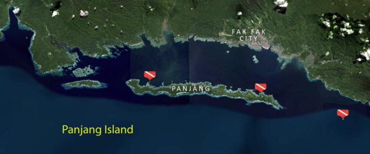
To access each area’s dive site info including maps, GPS coordinates, dive directions, surrounding activities and images, open the website, hover over and/or click on Maps in the top tier menu.  Click on Bomberai/Fakfak to bring up the regional map.  This map contains yellow circles for all the areas we surveyed.  Click on the Fakfak & Panjang circle (now yellow with a flashing red halo).  Hover on a dive flag to highlight a dive site.  Then click on the flag to bring up that site’s information.  Or simply click here to go directly to the Fakfak &
Panjang Map with the dive site flags.

This is the third in the series of posts about the new sites.  The new areas we have completed, they are indicated by a flashing red circle on the regional Bomberai/Faklfak map.  As each additional area’s info is uploaded the area’s yellow circle will flash red, indicating that area is now actionve with dive site information.

At the moment Fakfak is barely on most divers “bucket list”.  Our intent and the reason for this survey is to expand the tourism opportunities in the Bird’s Head Seascape, assist locals in generating income, while using the LOB’s presence to patrol the area for illegal activities.  More exploratory work needs to be done in his little known and basically unexplored region but this survey provides a huge leap forward.

A huge thanks to our web designers at New Media Soup, Joel and Jennifer Penner and to master map maker, Garry Bevan.  Garry is a renaissance man!  Besides making maps he’s a cruise director, author, content creator, dive tech and a musician.  He is presently working on a series of dive and cruising guides of Indonesia.  If you need someone to sort things out, while making you laugh, Garry is your man.  Without the assistance of the Pindito and it’s owner Edi Frommenwiler this trip would not have been possible.  So a big shout out of thanks go to them as well.

About the Author

Social Share

  • google-share

Twitter: @BHSeascape

Twitter feed is not available at the moment.

Tags

Berita Terkini Bird's Head Seascape Cenderawasih Bay conservation Conservation Coral Triangle cruising discovery diversity diving ecology education endangered species environment Fakfak illegal fishing Indonesia initiatives Kaimana Leopard shark mangrove Manta Ray Marine Protected Area Misool MPA news new species park rangers photography protected areas raja ampat science Science scuba shark snorkeling sustainability tourism town meetings triton bay turtle underwater photography West Papua whale shark Zebra shark

Categories

  • Berita Terkini
  • Biodiversity
  • Biodiversity/Taxonomy/Ecology
  • Biogeography
  • Birdwatching
  • Bomb Fishing
  • Cetacean
  • Conservation/Science
  • Coral restoration
  • Diving
  • Drone photography
  • Ecology
  • Education
  • Epaulette Shark aka "Walking Shark"
  • Forestry
  • Manta Ray
  • Marine Protected Area
  • media
  • Natives
  • Nelayan bom
  • Nickel Mining
  • Painting
  • Photography
  • Ranger Patrol
  • Re:wild
  • Regional
  • Research
  • ReShark
  • Rewilding
  • ReWilding a species
  • Scuba
  • Shark Ray 360
  • Snorkeling
  • StAR
  • Taxonomy
  • Terra Papua
  • Tourism
  • Training
  • Trekking
  • underwater photography
  • Underwater Videography
  • USBA Institute/Institut
  • Videography

Archives

Recent Posts

  • Shark Ray 360: ReShark’s 2nd affiliate Project
  • ReShark Ramblings #12 by Dr. Mark Erdmann
  • Update: Chinese Diver Accused of Killing and Eating an Endangered Species from Kompas.com
  • Misool Newsletter: Season 19 has begun!
  • Jangkar-The Indonesian Liveaboard Association, A Valuable Resource
  • The ReSharker Newsletter Issue #9 by Nathaniel Soon, Et al.
  • ReShark Ramblings #11 by Dr. Mark Erdmann
  • Indigenous Community School Development by USBA Institute w/ Terra Papua (English)
  • Sekolah Adat, Bangun Sistem Regenerasi Penjaga Raja Ampat USBA Institut: Siaran Pres (Bahasa)
  • Tourism, climate puts Raja Ampat’s ‘walking shark’ under pressure
  • Introducing Terra Abadi Papua: Managing Raja Ampat’s “Growing Pains”
  • Populasi Hiu Berjalan di Raja Ampat Mencatat Kepadatan Tertinggi di Dunia: Bukti Pentingnya Perlindungan Habitat Terumbu Karang, oleh Edy Setyawan et al.
©Bird's Head Seascape, All Rights Reserved.