


BHS Whalesharks “Get Around”: The 9 most interesting tracks by Mark Erdmann, Abraham Sianipar and Megan Meyers
BHS Whalesharks “Get Around”: The 9 most interesting tracks
by Mark Erdmann, Abraham Sianipar and Megan Meyers
The following is adapted from the Conservation International: Human Nature blog
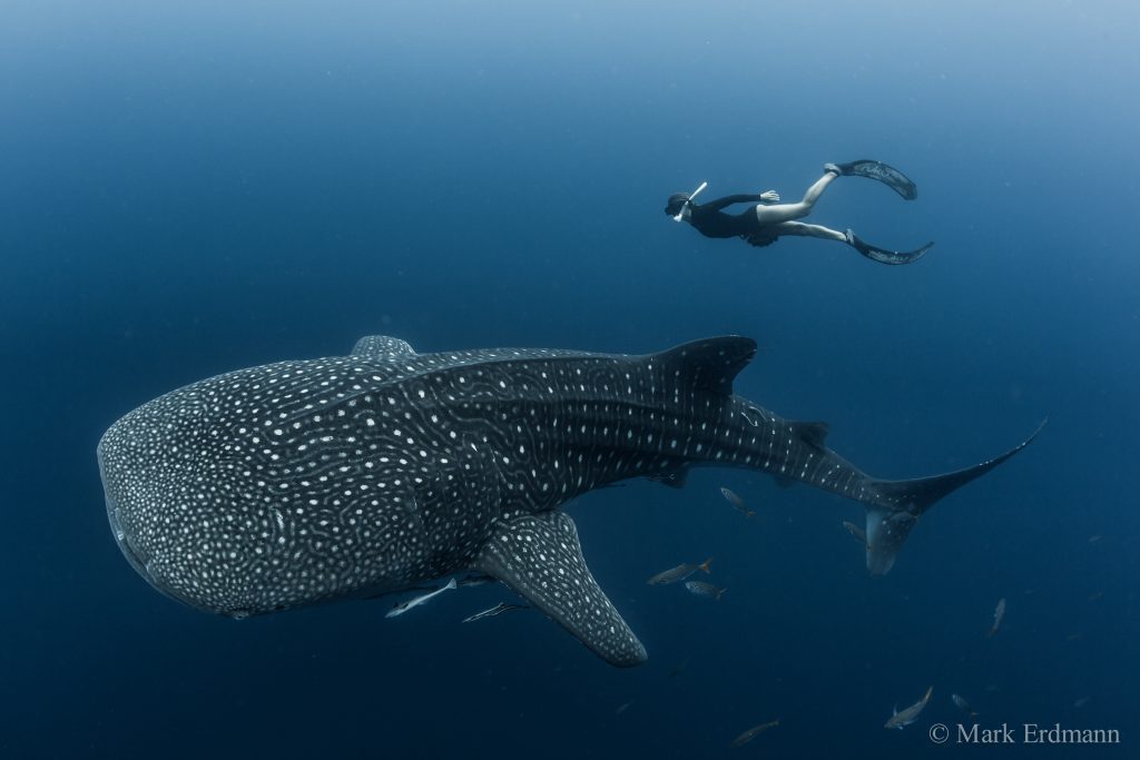
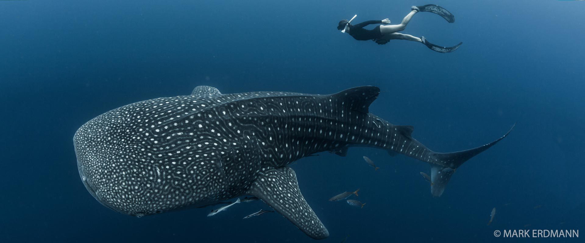
Sarah Lewis of Manta Trust swims with a whale shark in Cendrawasih Bay in the Bird’s Head Seascape. CI scientists have been satellite tracking the movements of Cendrawasih’s whale sharks since June 2015. (© Conservation International/photo by Mark Erdmann)
It’s now been just over two years since we successfully deployed the world’s first finmount satellite tags on whale sharks in Cendrawasih Bay – and with one of these original tags still transmitting, it seems a perfect time to reflect on what we’ve learned of these magnificent animals since launching the tagging program in collaboration with the Cendrawasih Bay National Park Authority (BBTNTC), the State University of Papua (UNIPA) and the Ministry of Marine Affairs and Fisheries.
As those who follow the BHS website know well, we’ve been able to directly attach these satellite tags to the dorsal fins of the world’s largest fish – allowing us to receive real-time position data on the sharks each time their fin breaks the surface of the water. Since that initial expedition in June 2015, we’ve managed to deploy the custom-made satellite tags on twenty-two whale sharks in Cendrawasih Bay and, most recently, on an additional five sharks in Kaimana.
Perhaps the most surprising finding from this ground-breaking tagging program has been just how differently each of these sharks has behaved. While we expected to see some “generalized tracks” of migrations of the sharks out of the Bird’s Head, in reality every shark has largely done its own thing! Some have remained close to home, while one travelled over 5,100 km from West Papua – but each satellite track has revealed unique behaviors. Below we summarize our picks for the top 9 most interesting tracks from whale sharks tagged in the Bird’s Head Seascape over the past two years.
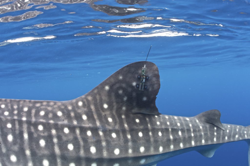
One of the custom finmount satellite tags designed for us by Wildlife Computers to track Bird’s Head whale sharks for up to two years! Each time the shark’s fin breaks the surface of the water, the tag’s antenna is able to communicate with the ARGOS satellite network and send data on the shark’s position and its recent diving behavior. Importantly, the tags are first coated with Propspeed (generously donated by Oceanmax in New Zealand!) to prevent fouling of the tags by barnacles and algae. (© Conservation International/photo by Mark Erdmann).
The Homebody
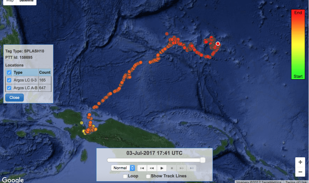
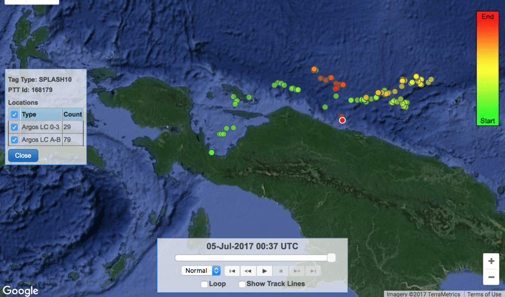
The 4.5m long whale shark “Sharky McSharkface” (who incidentally was named in a CI online naming contest) is now a world record holder for the longest satellite tag data series from a whale shark – his tag has been transmitting now for 25 months continuously, which is all the more impressive given that these satellite tags are outfitted with a battery pack designed to provide up to a maximum of two years’ of transmissions. During this time period, Sharky has been largely a homebody to Cendrawasih Bay – only venturing out of the bay for a short time in late December 2016. He has recorded some impressive dives of up to 1288 m deep during this time, however!
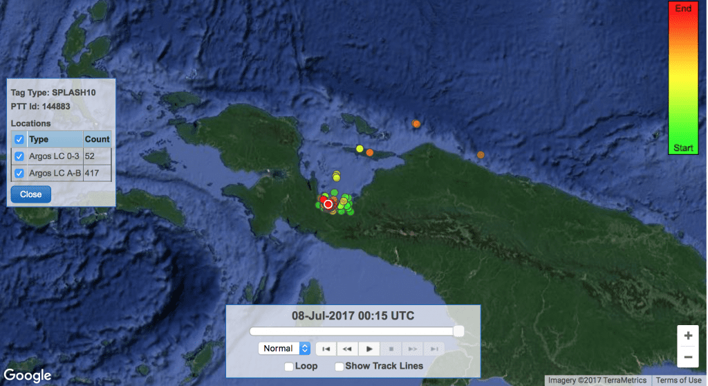
Map showing the satellite track of Sharky McSharkface. Green dots indicate position data from the beginning of the deployment (from June 2015), while the increasingly darker dots show position fixes from later on in the deployment. The red dot with the white outline indicates the shark’s most recent position in Cendrawasih Bay in July 2017. (© Conservation International).
The Deep Diver
Speaking of deep diving, 6m-long “Moby” recorded one of the deepest known dives for whale sharks (1856 m!!!) during his impressive travels north from Cendrawasih Bay to the southern Mariana Trench. Interestingly, he made this northerly loop between March and June 2016, then did a short jaunt westwards to Raja Ampat before returning to Cendrawasih Bay for about 8 months. In March 2017, he looked to be repeating his northern migration but has unfortunately not sent any further position data since that time!

Moby made numerous dives below 1500 m during his travels up to Palau and Yap at the southern end of the Mariana Trench. His total track length reached 6270 km before he stopped transmitting position data in March 2017 (© Conservation International).
The Coastline-hugger
“Wally” (a 6m male) laid down a very unusual track during the 15 months his tag was active. During this time, he left Cendrawasih Bay and closely hugged the coastline of New Guinea, stopping for weeks at a time at the large river outlets he encountered along the way! All we can figure is that he was targeting the baitfish schools that tend to be abundant in the coastal waters off these big estuaries. He made it nearly as far as Wewak and the Sepik River outlet in Papua New Guinea, but then moved back and forth along the coastline repeatedly. He returned to Cendrawasih Bay for a short time and then back down the coast – clocking 3800 km during his 15 month travels.
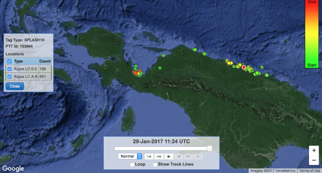
Wally showed a unique behavior of hugging the New Guinea coastline for his entire track, stopping only at the mouths of large river outlets (apparently to feed). He covered 3800 km during his travels. (© Conservation International).
Tracing the Banda Arc
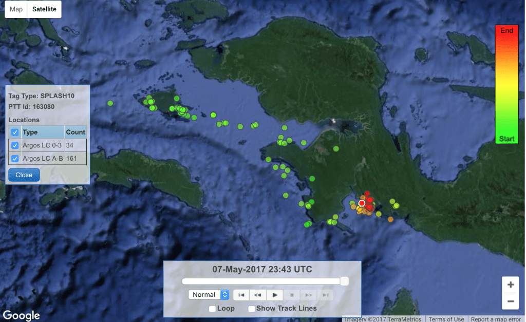
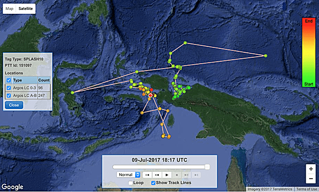
“Kaimana”, a 4.5m long male, was the first whale shark we tagged in the Triton Bay area in the southern Bird’s Head Seascape in December 2016. In the eight months since he was tagged, Kaimana has travelled nearly 4000 km while making first a southwesterly loop (tracing the outer Banda Sea island arc down to southern Timor-Leste and then back to Triton Bay) and then a northern arc along the FakFak coast up to southern Raja Ampat. Along the way he’s dived to 1250 m in depth!
Kaimana was initially tagged in December 2016 in Triton Bay in the southern Bird’s Head, and has since that time made a large crescent-shaped track along the outer Banda Sea volcanic island arc – south to Timor-Leste and north to Seram and Misool in Raja Ampat. (© Conservation International).
The Southern (Bird’s Head) Man
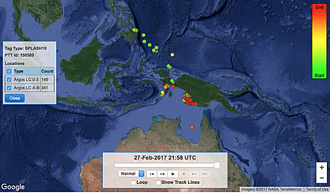
“Muarwa Barnacles”, a 6m long male, was yet another of the first whale sharks we tagged in the Kaimana area, this one in February 2017. In the five months since he was tagged, Muarwa Barnacles has travelled nearly 1800 km while tracing an arc along the southern Bird’s Head – along the FakFak coast up to southern Raja Ampat (including a long time in SE Misool) and then back to Kaimana. Along the way he’s dived to 488 m in depth!
Muarwa Barnacles is another of the five whale sharks we’ve tagged in the Kaimana region so far. Since February 2017, he’s traced the Kaimana and FakFak coastlines up to Raja Ampat and then back to Kaimana’s Triton Bay. (© Conservation International).
The International Man of Mystery
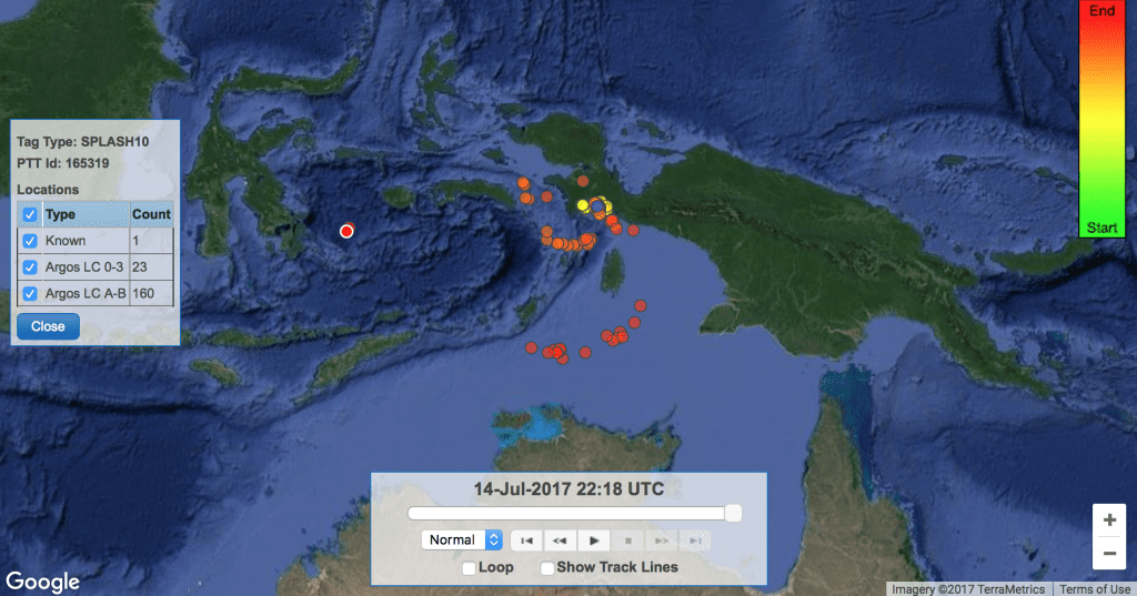
“Kodo” has won the contest for West Papuan whale shark with the most stamps in his passport – the 4m male swam northwest from Cendrawasih Bay into the waters of Palau, then visited Mindanao in the Philippines, then back down to Indonesia, into Australia’s Gulf of Carpentaria, and then back to southern Papua. He’s covered over 8400 km since being tagged in March 2016, and has spent the majority of the past 9 months in the vicinity of Merauke in southern Papua. This is particularly interesting given this is a mangrove swamp and mud-flat region – not the type of habitat we usually think of for whale sharks! We’re not exactly sure why he’s spent so much time in these shallow muddy waters – but presumably he’s found a food source that keeps him happy!
Kodo has hit four countries in his 16-month deployment (Indonesia, Palau, Philippines, and Australia) and has spent an unusually long amount of time in the mud-flat and mangrove swamp region of Merauke in southern Papua. (© Conservation International).
The Surface Swimmer
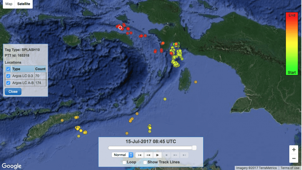
“Cheggers” was tagged in November 2016, and after spending a few months in Cendrawasih Bay, decided to take a long trek to the northeast. The 5.6m male has stayed mostly on the surface during his 2915 km swim over to Yap and Chuuk in the Federated States of Micronesia, though he did occasionally dive as deep as 1375m!
Cheggers has spent an unusual amount of time swimming predominantly along the surface while crossing very deep water up to Yap and Chuuk island groups in Micronesia – though he did go as deep as 1375m at one point! (© Conservation International).
The Vulcan
“Spock” is one of the larger whale sharks we’ve tagged at 6.7m in length. He was tagged in February 2017 in Bitsyari Bay in Kaimana, and after spending a few months in the Kaimana area, began to explore the waters off the southern Bird’s Head (FakFak, Kai and Aru Islands and close to Seram) before heading further south into the Arafura Sea close to the border with Australia. Most recently, he’s made the westernmost movement we’ve yet seen of any of our tagged sharks, crossing into the Banda Sea and is now just north of Wakatobi and moving towards Kendari on the Sulawesi coastline. Live long and prosper, Spock – we’re looking forward to learning the logic of your movements!
Spock is another recently tagged whale shark that has made some impressive movements in the five months since he was tagged – now just north of Wakatobi National Marine Park (© Conservation International).
The Long Distance Champion
Interestingly, the whale shark with the longest track length is also one of the smallest sharks we tagged! “Fijubeca” was only 3m in length when we tagged him in October 2015, but since that time he’s travelled over 9000 km on a track which led him first north into Palauan waters, then east into PNG, then over to the Indonesian island of Sulawesi, and then back to southern Raja Ampat and the FakFak coastline in West Papua, where he’s spent most of the past year (with a short excursion south of the Aru islands then back to Raja Ampat). The little shark has dived as deep as 880m during his 21-month tag deployment!
Equally as impressive, Fijubeca has visited eight of the Marine Protected Areas (MPAs) in the Bird’s Head Seascape during his travels!! This makes us particularly happy, as it indicates we’ve done a good job of siting these MPAs in areas that are important to marine megafauna migratory routes. To that end, I’d also note that the tracks of Fijubeca and other tagged sharks have drawn attention to the importance of the FakFak coastline and the Pisang Islands in Bintuni Bay (where we now have 3 MPAs worthy of further diving exploration!) as well as Mapia Atoll north of Biak (where there is no current MPA, but discussions are now taking place with the local community).
Fijubeca has travelled over 9000 km during his 21-month deployment, diving as deep as 880m while visiting 8 of the MPAs in the Bird’s Head Seascape network. (© Conservation International).
Bonus Track!!
Though we promised nine shark tracks, we’re adding a “bonus” track for an up and coming star: “Nexus”, a 4m male named in honor of the Nexus school in Singapore, whose students sponsored this shark’s tag. Nexus is our most recently-tagged shark (mid-April 2017), but he’s wasted no time in making an impressive 3000 km journey out of Cendrawasih Bay and back and forth along the continental shelf edge off northern New Guinea. He’s apparently feeding in/over very deep water (perhaps on localized upwellings?), as evidenced by the fact he’s also logged a number of 1000m+ dives – with his deepest so far being 1250m! We’re very much looking forward to what this ambitious little shark does in the coming months…
Nexus has logged over 3000 km in his journey since leaving Cendrawasih Bay in late April 2017! (© Conservation International).
A look to the future…
Our collaborative whale shark satellite tagging program has provided a wealth of unique insights into the secret lives of the world’s largest fish, and we are now using this information to formulate recommendations to improve the management of whale shark tourism in the Bird’s Head. Importantly, the satellite tracks we’ve recorded have highlighted several regions of West Papua that are frequented by migrating whale sharks that are now being considered for development of additional marine parks. In the near future, we are planning a major expedition in collaboration with the Georgia Aquarium and the Indonesian government to assess the health of Cendrawasih’s whale shark population and specifically investigate whether current tourism practices are sufficiently “whale shark friendly”, or if they are causing undue stress to the sharks and requiring of additional management interventions. Stay tuned for more details next month…
Mark Erdmann is CI’s Vice President for Asia Pacific Marine Programs, now based in Auckland after 23 years in Indonesia.
Abraham Sianipar is CI’s Indonesian Elasmobranch Conservation Science Specialist, based in Jakarta.
Megan Meyers is a shark scientist who recently completed her Master’s degree at the University of Auckland analyzing the data from a number of satellite-tagged Cendrawasih Bay whale sharks.
Mark, Abam and Megan would like to specifically acknowledge the generous support of guests of the True North expedition vessel, CI donors including the Wong family, the Allchin family, Daniel Roozen, Matt Brooks, Pam Rorke Levy, Marie-Elizabeth Mali, Enki Tan, and the Nexus school in Singapore, and Oceanmax/Propspeed and the University of Adelaide’s Centre for Applied Conservation Science for supporting the whale shark satellite tagging program in West Papua.